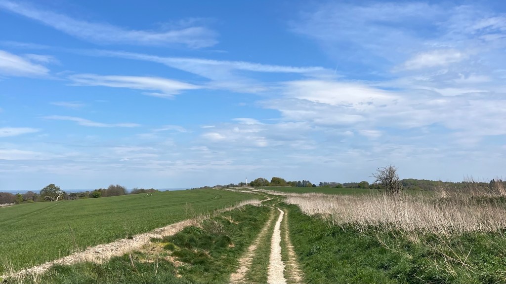
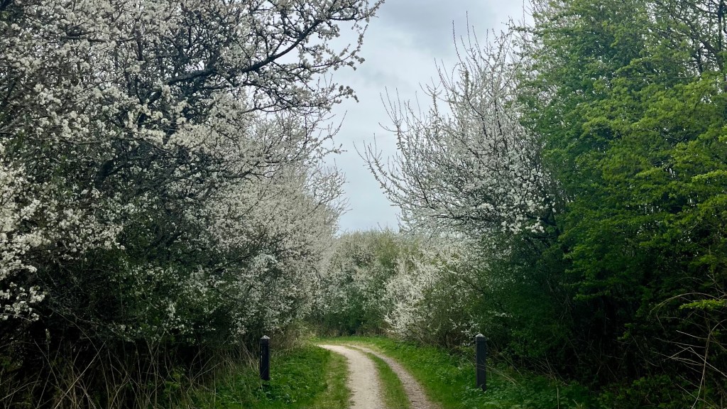
For over 5,000 years people have travelled the Ridgeway, Britain’s oldest road, tracing a chalk ridge that stretches from Overton Hill in Wiltshire to Ivinghoe Beacon in Buckinghamshire. The trail traverses rolling chalk downs, open fields and patches of ancient woodland, as hikers follow in the footsteps of farmers, traders, travellers, farmers and soldiers past.
I section-hiked the trail in April 2025. For a closer look at the on-the-ground experience, head over to my Ridgeway: Trail Journal post for my stats, budget, photos and story.
- Quick Facts
- Map & Elevation Profile
- Preparation
- On-Trail Practicalities
- Side Missions & Connecting Trails
- Hiking as a Solo Woman
- Want More?
Quick Facts
| Distance | 140 km |
| Elevation gain & loss | + 2,470 m / -2,385 m |
| Days to complete | 5-7 |
| Best season | Spring (April) to Autumn (October) |
| Trailheads | Overton Hill, near Avebury; Ivinghoe Beacon, near Tring |
| Recommended direction | Either way! |
Map & Elevation Profile
Preparation
Trailheads & getting there
The traditional start to the trail is in Overton Hill, near Avebury. They’re nearest train stations are Swindon and Malborough: from either, you’ll need to get either a bus or a taxi to the trailhead.
The trail ends in Ivinghoe Beacon, situated in the National Trust Ashridge Estate. The nearest train stations is Tring.
Direction to Walk
In my opinion there are no major pros or cons to hiking in any particular direction, although some say that starting in Overton Hill is a gentler way to ease into the trail. I chose to start there because for me it was more challenging to get public transport to this end of the trail from London.
Season to Walk
Hiking is possible year-round on the Ridgeway, though in winter be prepared for shorter days, more mud and fewer accommodation options.
Accommodation
Beds & Bunks
The trail doesn’t actually run through many towns or villages, but there are a handful within a kilometre or two of the trail where you’ll find at least one accommodation option, from hotels to pub stays to B&Bs. The Ridgeway is a very popular trail and accommodation can be difficult to come by; booking ahead, particularly in summer, is wise.
Camping
Wild camping is not permitted in England, but there are sufficient commercial campsites along the route that the entire trail could be done with a tent. And a bonus is that several of these are located almost directly on trail, so you’ll save yourself the extra mileage into a village. However, these are generally only open during the main season. When I hiked in mid-April, some were still closed.
Gear List
If you’re staying in accommodation, you can pack light:
- 25L pack (or smaller!)
- 1x shirt and bottoms for walking + extra set or alternative town clothes
- 3x socks and underwear
- PJs
- Fleece & puffer jacket (in cooler months)
- Rain gear
- Sunglasses, hat / beanie
- Trail runners / hiking shoes
- Electronics
- Toiletries & first aid
- Water bottles
You don’t need anything more on this trail, unless you’re camping, in which case you’ll obviously need to add your tent, sleep system, cooking gear and possibly a light towel.
Possible Stages
In this table I’ve listed the same stages given by National Trails. In-between, I’ve inserted the names of a couple of small villages that are slightly off-trail that seem to have at least one pub stay option. AirB&B may mean that other villages are also feasible. Keen observers will figure out that some of the National Trails stage ends are also slightly off-trail.
| Place | Distance from previous (km) (W2E) | Distance from previous (km) (E2W) |
|---|---|---|
| Overton Hill | 0 | 14.8 |
| Ogbourne St George | 14.8 | 25.6 |
| Badbury / Liddington / Wanborough / Bishopstone / Ashbury | Off-trail | Off-trail |
| Sparsholt Firs | 25.6 | 27.9 |
| Letcombe Basset / Wantage / East Ilsley / Compton / Aldworth | Off-trail | Off-trail |
| Streatley / Goring | 27.9 | 24.6 |
| Winterbrook / Wallingford | Off-trail | Off-trail |
| Watlington | 24.6 | 27.2 |
| Aston Rowant / Kingston Blount / Chinnor / Princes Risborough | Off-trail | Off-trail |
| Wendover | 27.2 | 18.8 |
| Wigginton | Off-trail | Off-trail |
| Ivinghoe Beacon | 18.8 | 0 |
On-Trail Practicalities
Finding Your Way
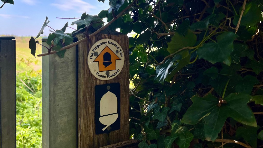
Trail Markings
It’s pretty hard to get lost on the Ridgeway: centuries of footsteps have beaten out an unmistakable path. Just in case you’re in doubt when you reach an intersection, the National Trails’ upside-down acorn will steer you. However, you’ll still want a map of some kind to help find your accommodation and other mid-hike town stop options (pub meal, anyone?).
Maps & GPX
There’s the official National Trust GPX file of the route, which you can add to your app of choice – I like Garmin Explore. You could also check out the OS Maps app. Ordnance Survey paper maps are also available.
Guidebooks & Resources
This is a popular trail, so you have your pick of guidebooks: from the Trailblazer and Cicerone options, to an official National Trails guide. That said, unless you want a convenient collection of notes on the history, geography, flora or fauna, you can walk the trail without a guidebook – I did.
Food & Water
Since the trail largely avoids towns and villages, you’ll want to carry all the water, lunch and snacks you need for the day. If you’re detouring to accommodation in a village, there will almost certainly be a pub, cafe and/or small convenience store where you can fill up on dinner and breakfast. Many accommodation providers cater to hikers, and will offer early breakfasts and packed lunches, but best to confirm in advance. Supermarkets and grocery stores are less common, but available in Wendover, Princes Risborough and Tring.
Reliable water sources are limited, so it’s best to carry all the water you think you’ll need for the day. Most of the trail traverses farmland, so if you’re drinking from a natural source don’t forget to filter.
On-Trail Transport
It’s not too difficult to find a public transport option close to trail. There are train stations at Goring & Streatley, Wendover and Tring, all very close to the trail. Local buses also run through most villages just off trail; but you’ll want to check the timetable as services can be infrequent.
Money Matters
Leave your cash at home; card accepted everywhere.
For a breakdown of what I spent on-trail during a public holiday weekend, see my Ridgeway: Trail Journal.
Side Missions & Connecting Trails
There’s no shortage of detours from the Ridgeway, starting with the many quaint villages just off-trail including Lambourn, Princes Risborough and Tring. History buffs will be tempted by the Uffington White Horse (basically on-trail) and Whipsnade White Lion (an hour or so from Ivinghoe Beacon, visible at a distance from Ashridge Estate), ancient chalk figures carved into the downs. Other options include Uffington Castle, an Iron Age hillfort, and Wayland’s Smithy, a neolithic long barrow; both located near the Uffington White Horse.
If you’re looking to stretch your adventure further, the Ridgeway intersects with other long distance trails including the Thames Path and Icknield Way Path.
Hiking as a Solo Woman
This trail is popular year-round with day-hikers and thru-hikers alike, making it a great option to travel solo. I never felt unsafe or even on edge, exit options to nearby villages are plentiful, and mobile reception was good throughout.
Want More?
Check out my Ridgeway: Trail Journal for stats, stories and snapshots from the trail.

Leave a comment