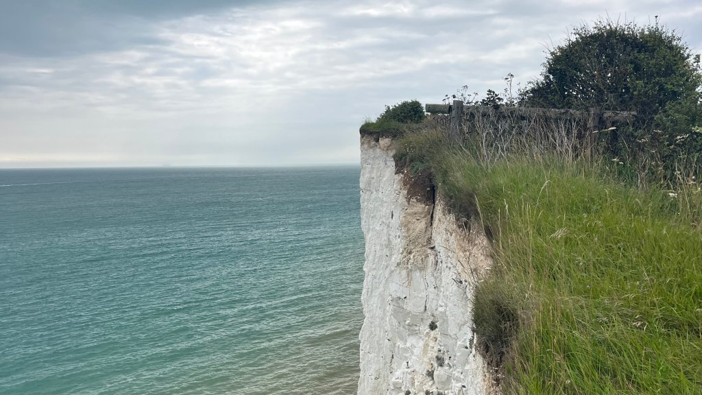
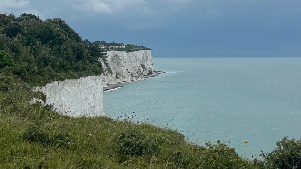
What better way is there to spend the summer than hiking 250 kilometres along the south east coast of England? The Saxon Shore Way follows a line of crumbling Roman defenses built as trading posts and to guard against coastal raids. These forts once sat on the edge of the sea, but now lie miles inland thanks to centuries of erosion, flooding and land reclamation. The trail showcases the entire character of the English south east, featuring estuaries, marshes, farmland, seaside villages and cliff-top paths.
I section-hiked the trail between July and September 2025. For a closer look at the on-the-ground experience, head over to my Saxon Shore Way: Trail Journal post for my stats, budget, photos and story.
- Quick Facts
- Map & Elevation Profile
- Preparation
- On-Trail Practicalities
- Side Missions & Connecting Trails
- Hiking as a Solo Woman
- Want More?
Quick Facts
| Distance | 258 km |
| Elevation gain & loss | +3,175 m / – [x] |
| Days to complete | 11-13 |
| Best season | Spring (April) to Autumn (October) |
| Trailheads | Gravesend; Hastings |
| Recommended direction | Clockwise |
Map & Elevation Profile
Preparation
Trailheads & getting there
Gravesend sits at one end of the trail, easily accessible on the London public transport network; you can tap on and off, no need to buy a ticket.
At the other end of the trail lies Hastings. Trains regularly run between here and London: you’ll need to buy a ticket.
Direction to Walk
The trail can be hiked in either direction, but walking clockwise and ending in Hastings will be the more satisfying finish: it’s a gorgeous seaside town rich in history and with a lovely beach to recover on. The official end of the trail is Hastings Castle, built following the famous battle of 1066.
Season to Walk
The trail can be walked year-round, but since you’ll be so close to the ocean you might prefer to walk between Spring (April) and Autumn (October).
Accommodation
Beds & Bunks
There are plenty of options for accommodation on the trail, including hotels, B&Bs and pubs for the quintessential English experience. Hostels are also available in some of the larger towns.
Camping
Wild camping is not permitted in England. Some paid campsites are available close to the trail, however when I looked into it I couldn’t figure out a way to do the entire trail by staying at these: they’re too few and far between. But I did spend one weekend walking back to back days, and camped in between, which was a lovely way to escape London for a little while.
Gear List
I largely day hiked, returning to London each night, so my gear was pretty light on:
- Small backpack (or try a running vest!)
- Water bottles
- Fleece and / or rain jacket (depending on the forecast)
- Snacks, of course
- Hiking clothes
- Hiking shoes or trail runners
If you’re spending a little longer on trail, you’ll want to consider adding:
- A second set of hiking clothes and / or town clothes
- PJs
- Electronics
- Toiletries
- Towel (if not provided by your accommodation)
And of course if you do camp some sections, bring your tent and sleep system, and maybe some poles for the hillier second half of the trail. You could bring a cooking kit, or rely on the kitchens at commercial campgrounds (BYO utensils and pot or bowl, though).
Possible Stages
| Place | Distance from previous (km) (DIR) |
|---|---|
| Gravesend | 0 |
| Cooling | 14.5 |
| Strood / Rochester | 18 |
| Chatham* | 3 |
| Gillingham* | 3.5 |
| Lower / East Rainham* | 7 |
| Lower Halstow* | 9.5 |
| Swale* | 12.5 |
| Sittingbourne* | 9 |
| Faversham | 17 |
| Herne Bay | 24 |
| Plucks Gutter | 17.7 |
| Sandwich | 13.6 |
| Deal | 22 |
| Dover | 19.3 |
| Folkestone | Off-trail, but has a convenient train station |
| Etchinghill | 21 |
| Hamstreet | 24 |
| Rye | 19.3 |
| Winchelsea | 6.4 |
| Hastings | 14.5 |
* Disclaimer that I have made an educated guess-timate of these distances; I couldn’t find any sources listing them, and I didn’t calculate my own stages factoring these potential stops in.
On-Trail Practicalities
Finding Your Way
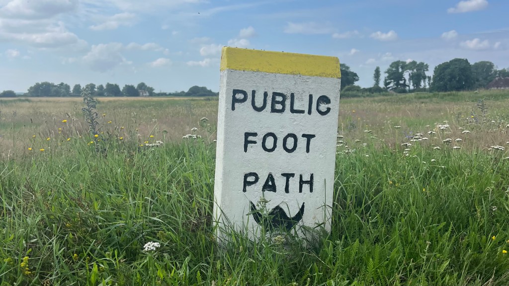
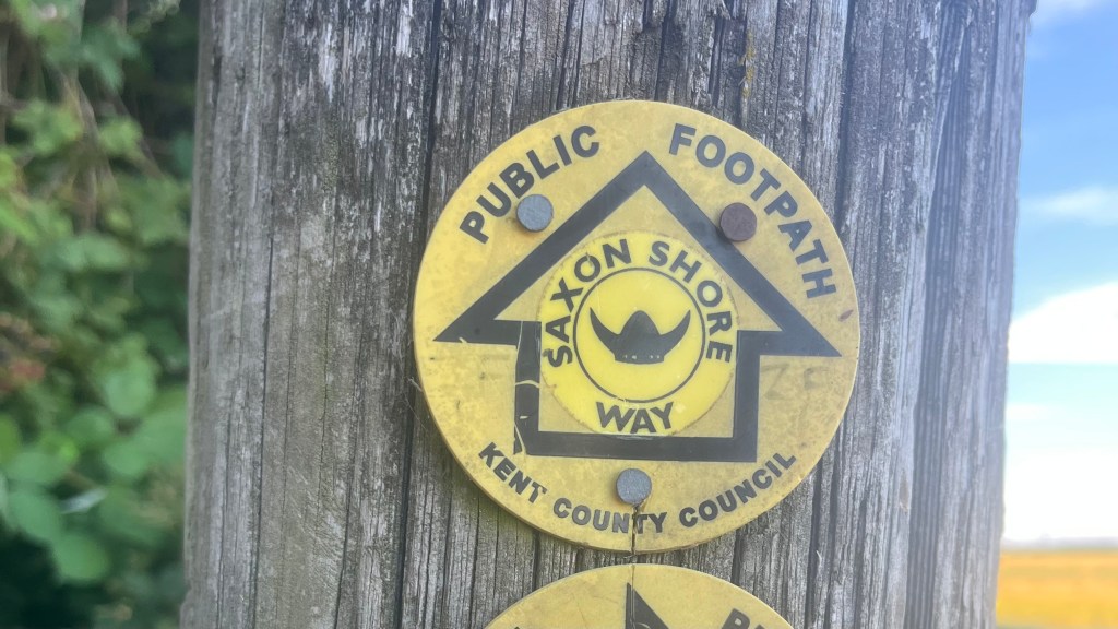
Trail Markings
You’ll be following a viking helmet on a disc, which appears in a few different colours along the trail. Markings were good in some sections, but quite poor in others. There’s a bit of overlap between this trail and the England Coast Path and the North Downs Way, and sometimes you’ll need to follow the markings for those trails instead. You may also need to reroute: when I completed the trail, there were a few sections that were too overgrown to bushwhack. If you’re a purist, or just not a fan of getting even a tiny bit lost, take a map or app.
Maps & GPX
There were a couple of sections of trail, especially along the first few stages out of Gravesend, where the path was seriously overgrown with blackberries and / or stinging nettles and I had to reroute: so I recommend bringing a map or app with you. The OS Maps app would be a good option; I downloaded a GPX file from The Walking Englishman, which I added to my Garmin Explore app. If you prefer a paper map, look into the Ordnance Survey series.
Guidebooks & Resources
It seems that the only published guidebook for this trail is currently out of print, and there aren’t any “official” walking notes published online. But there are a few blog posts out there that can give you an idea of what to expect, although check the date: this doesn’t seem to be a super popular trail.
Food & Water
The trail passes through many towns and villages, almost all of which boast a pub and / or cafe. Many of them also have large supermarkets, although these may require a short detour off-trail. I’d recommend having your lunch stop planned out, or bringing it from home. And of course always have some snacks packed.
I don’t recall there being many natural water sources on this trail; and most of it runs through farming land, so you’ll want to filter any natural sources you do come across. There also weren’t many places where you could fill your own water bottle up; but you can ask politely at a pub or a cafe and they’ll almost certainly help you out.
On-Trail Transport
There are excellent public transport connections at the beginning and end of most stages. They’re so good that it’s easy to section-hike this trail from London on weekends without any trouble. Booking an Advance Single ticket, and getting your hands on a Railcard, will save you a good deal of cash; but if you’re not a planner, that’s fine too, you’ll hav enough trouble getting a ticket on the day. In-between stage ends, public transport can be limited; plan ahead, or have a taxi number on hand.
Money Matters
Cash is unnecessary; card will see you through. Head over to my Saxon Shore Way: Trail Journal post for a breakdown of what I spent on trail.
Side Missions & Connecting Trails
The main side missions on this trail will be to investigate the area’s history and geography. Many of the Roman forts can be explored within a few steps of the trail, and while the trail already winds through many diverse landscapes it’s only too easy to get up close and personal by taking other public footpaths.
The England Coast Path now overlaps with much of the trail, which offers plentiful opportunities for alternates and add-ons. Those interested in spending more time by the sea and avoiding inland might choose to combine the two between Herne Bay and Sandwich Bay, and / or between Folkestone and Rye. Other connecting trails include the North Downs Way and the Wealdway.
Hiking as a Solo Woman
The trail runs through a very populated area in the south east of England: it’s super safe, and you’ll see many people out for day hikes no matter the weather. Mobile phone service is excellent throughout. The first part of the section leaving Gravesend is unpleasantly industrial, but not unsafe.
Want More?
Check out my Saxon Shore Way: Trail Journal for stats, stories and snapshots from the trail.

Leave a comment