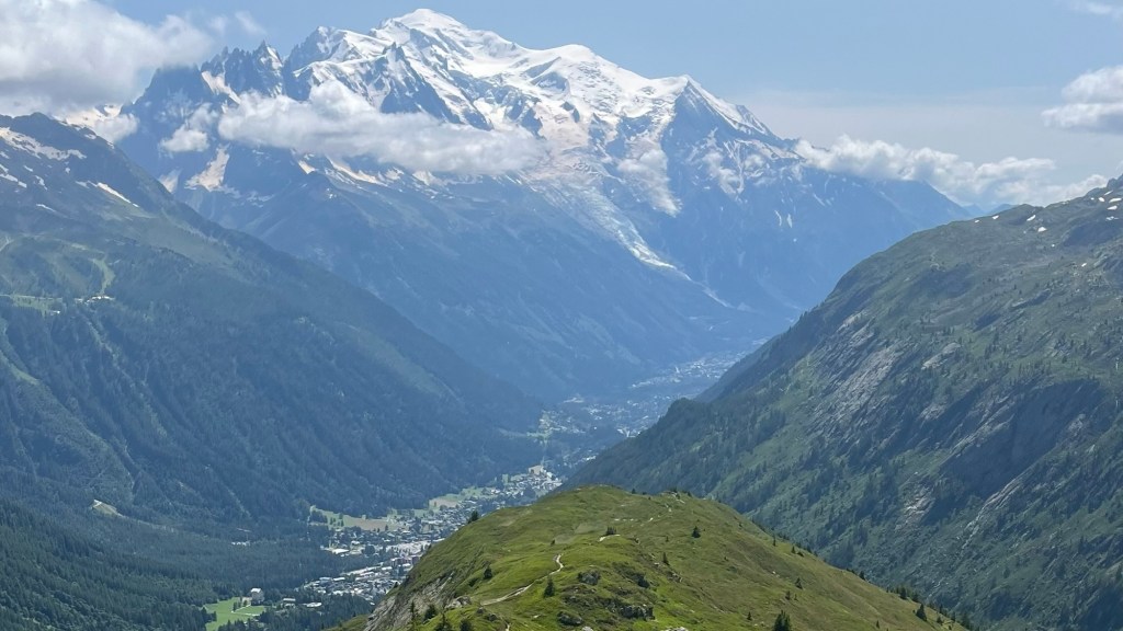
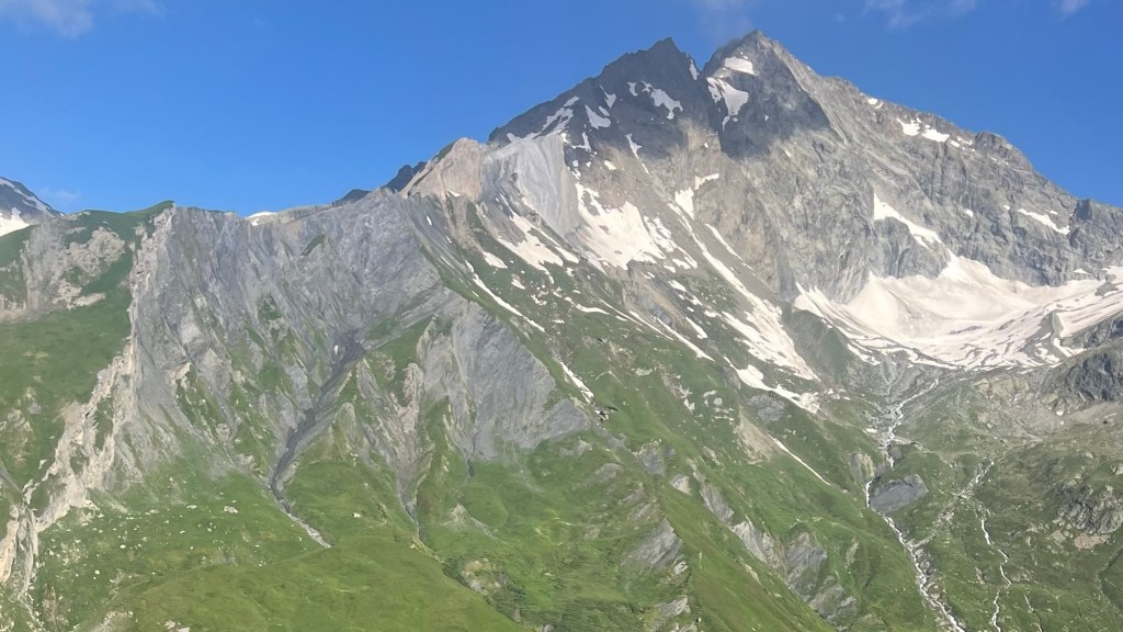
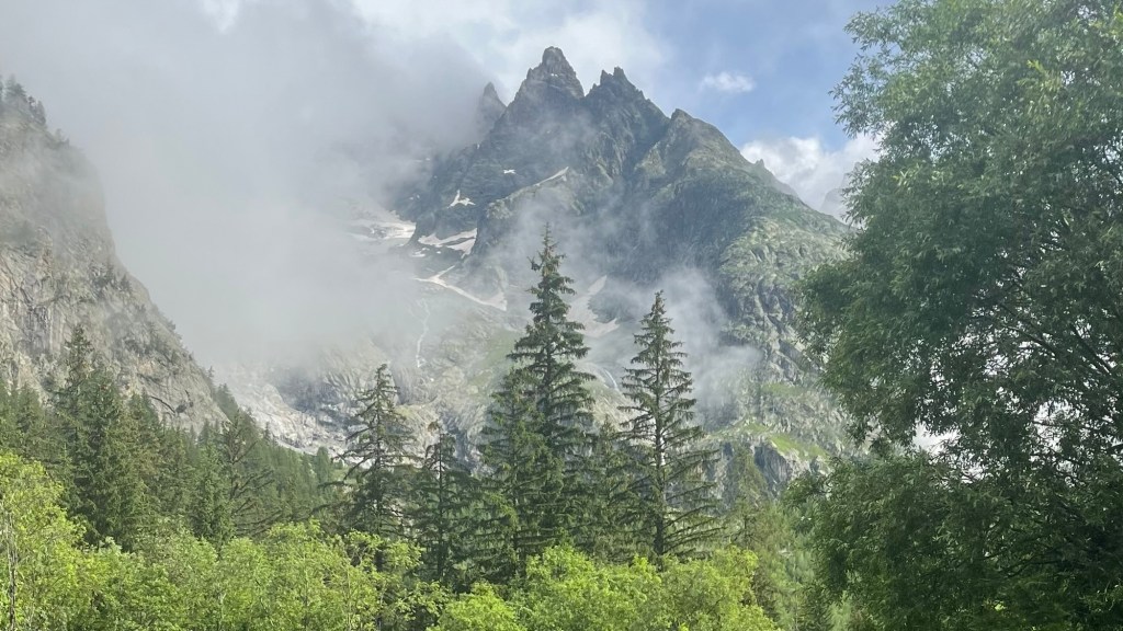
Constantly changing scenery, cultural immersion, and challenging climbs: the Tour du Mont Blanc has it all. Circumnavigating the Mont Blanc massif, the trail carries hikers through France, Italy and Switzerland via a stunning variety of alpine landscapes: from grand mountain passes to close-up views of glaciers, vast wildflower meadows to tranquil alpine lakes. Charming villages along the way provide an up-close and personal taste of multiple languages, cuisines and traditions, while a cumulative elevation gain greater than the height of Everest will satisfy those looking for a true physical challenge.
I thru-hiked the trail in July 2024. For a closer look at the on-the-ground experience, head over to my Tour du Mont Blanc: Trail Journal post for my stats, budget, photos and story.
- Quick Facts
- Map & Elevation Profile
- Preparation
- On-Trail Practicalities
- Side Missions & Connecting Trails
- Hiking as a Solo Woman
- Want More?
Quick Facts
| Distance | 170 km |
| Elevation gain | 10,000 m |
| Days to complete | 9-12 |
| Best season | July to August |
| Trailheads | Les Houches |
| Recommended direction | Anticlockwise |
Map & Elevation Profile
Preparation
Trailheads & getting there
As a circular trail, there are a couple of places to jump in:
- Courmayeur in Italy is one option, which can be reached by flight to Turin and then a regional train and connecting bus via towns including Torino and Aosta.
- Les Houches, France, is the most popular starting point; and for good reason. Starting here and heading anti-clockwise, you’ll build up to the biggest and best views on your final days. It also boasts the official terminus marker. Get there by flying into Geneva, Switzerland, and taking a bus to Chamonix. From there, a local bus can deliver you to Les Houches; or you can start your walk early by trekking the 8km to the village.
Direction to Walk
Most hikers tackle the trail anti-clockwise. There’s a reason: this way, you build up to the most impressive views, including a head-on view of Mont Blanc itself on the final day (if starting in Les Houches). The trail is also extremely popular, so walking this means you’ll be walking with, rather than against, the traffic. Having said that, when I was on trail, every day there was always a couple of large organised tour groups heading clockwise. They were a little frustrating to deal with, as it makes more sense for the smaller party to stop and wait for the larger party to pass, even if the smaller party would normally have right of way.
Season to Walk
The trail can generally be walked between late June and late September: this is when most refuges and camping outfits will be open. The big variable is the snow: it can linger even into July (I crossed a couple of sketchy patches in mid-July), or fall early in September.
Peak season is from mid-July to late August. Snow is likely to be gone, but the trail will be literally covered in hikers. If you don’t like crows, this is not the season for you: shoulder season is probably better suited.
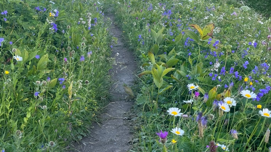
Between mid-June and mid-July, the trail is covered in wildflowers. This is when I walked it, and I couldn’t recommend it more heartily. The trail was busy, but it didn’t feel like a total crush of people. The other shoulder season is early to mid-September, when late summer colours will light up the landscape, while the crows have returned to work and school after their summer holidays.
Accommodation
Beds & Bunks
The main type of accommodation on the TMB is a series of mountain refuges or huts. These are generally operated by national alpine clubs, and offer dormitory-style beds and communal meals. They’re extremely popular; you’ll want to think about booking them around a year in advance.
Hotels and guesthouses are available in the larger towns along the route, including Les Houches, Les Contamines-Montjoie, Courmayeur, La Fouly, and Champex. Again, booking ahead is wise: these are all popular tourist destinations, for hikers and non-hikers.
Camping
Wild camping is not permitted anywhere on trail, although you could attempt to do so discretely. Given the popularity of the trail, there are some locals who are very unhappy with wild campers, and we heard a few stories of campers’ gear being stolen in the night.
It’s possible to complete the entire trail by staying in commercial campsites; be aware that these are usually down in the valleys, which means you’ll likely have an extra descent at the end of the day, and an extra ascent at the beginning of the next. None of these sites need to be booked in advance; all have designated sections for TMB hikers. The only booking you’ll need to make is for a permit to camp in the Aiguilles Rouges Nature Reserve; this is free, but bookings are essential: rangers check permits and we came across several people who had already set up camp but, without a permit, were forced to pack up and seek accommodation in the valley.
Gear List
To camp the trail you’ll want:
- 50-60L pack (or smaller capacity if you have UL gear)
- Trekking poles (this trail is the one that converted me into a trekking pole fanatic)
- Tent
- Sleeping mat
- Sleeping bag
- Stove
- Cooking gear: stove, pot, utensil(s)
- 1-2 sets hiking clothes
- Optional: refuge clothing
- Warm layer(s): in mid-July I took a fleece and a rain jacket, and the combo was sufficiently warm. You might want to think about a puffer jacket if hiking earlier, or in September or later
- Trail runners or hiking shoes
- Camp shoes
- Beanie / buff
- Sunglasses
- Hat / cap
- Gloves (we didn’t use these in mid-July, but worth considering)
- 3x socks and underwear
- Swimmers (or go in your underwear)
- Bank card & cash (Euros & Swiss Francs)
- Sunscreen & insect repellent
- Toiletries
- Electronics, including head torch and power bank (charging difficult between Champex and Les Houches)
Possible Stages
The trail is typically divided into 11 stages, which are set out in the first table below. But there are plenty of other refuges and accommodation options, so you can create longer or shorter or in-between stages.
You’ll have more limited options if you’re camping the trail. These are set out in the second table. As you’ll see, there are a number of options early on, but these fizzle out and require longer stages between Les Chapieux and Les Houches.
Typical 11 stages
| Place | Distance from previous (km) (anti-clockwise) |
|---|---|
| Les Houches | 0 |
| Les Contamines-Montjoie | 16 |
| Les Chapieux | 18 |
| Rifugio Elisabetta (or Rifugio Monte Bianco) | 15 (20) |
| Courmayeur | 18 (9 from MB) |
| Rifugio Bonatti | 12 |
| La Fouly | 20 |
| Champex-Lac | 15 |
| Trient | 16 |
| Tré-Le-Champ | 13 |
| Refuge La Flégère | 8 |
| Les Houches | 17 |
Camping stages
| Place | Distance from previous (km) (anti-clockwise) |
|---|---|
| Les Houches (Camping Bellevue) | 0 |
| Refuge du Fioux | 6 |
| Refuge de Miage | 7 |
| Les Contamines-Montjoie (Camping le Pontet) | 5 |
| Aire Bivouac La Rollaz | 5.5 |
| Aire de Bivouac de la Balme | 2.5 |
| Refuge du Col de la Croix du Bonhomme | 5.5 |
| Les Chapieux (wildflower meadow, pay at tourist office) | 5.5 |
| Off-route: Val Veny (Hobo Camping; Camping Aiguille Noire; Camping Monte Bianco La Sorgente) | 30 |
| Plampincieux (Camping Grandes Jorasses; Camping Tronchey) | 19.5 |
| La Fouly (Camping des Glaciers) | 19 |
| Champex (Camping Les Rocailles) | 15.5 |
| Trient (Camping de la Forclaz; Le Peuty) | 14 |
| Aiguilles Rouges Nature Reserve | 15 |
| Les Houches (Camping Bellevue) | 24.5 |
On-Trail Practicalities
Finding Your Way
Trail Markings
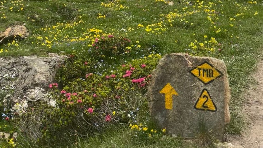
The trail is very clear and well-marked. You’ll be watching for a few different markers, including:
- In France, the Grande Randonée red and white marker (parallel lines = continue straight; bent lines = turn in the direction of the bend; cross = wrong way)
- In Italy, yellow lines, arrows or other geometric shapes like circles or diamonds. Occasionally these will be bordered in black and / or have a black “TMB” in the centre
- In Switzerland, white-red-white markers, similar to the GR ones in France
- In sections that can get snowy, markers may switch to yellow or orange patches of paint for visibility
- Some sections are supplemnted with a small, bright green square with a black “TMB” surrounded by a counterclockwise arrow
It pays to know the direction you’re heading in, as there are several signposts directing you to refuges and villages that aren’t actually on the TMB.
Despite the excellent calibre and frequency of markings, it’s worth bringing a map or app as in some sections markers have been lost to the elements, particularly on a few rocky scrambles.
Maps & GPX
If you like paper maps, you’ll need to gather a collection; or pick a guidebook that has good topo maps.
I prefer using GPX files, which I add to my Garmin Explore app. The trail is popular, so do your research to make sure you’re downloading something reputable. Most guidebooks will offer a free GPX download; another favourite method of mine is downloading a trail from the Fastest Known Time website.
Guidebooks & Resources
There are plenty of guidebooks to choose from, including Cicerone, Trailblazer and Knife Edge. Pick one that suits your hiking style. My research led me to Tour du Mont Blanc: The Most Iconic Long-Distance, Circular Trail in the Alps by Kingsley Jones.
I found a guidebook on this trail really useful, mostly because I found the online information available about it, particularly how to camp it, confusing and difficult to research.
Food & Water
Refuges and huts along the way offer a range of small snacks, packed lunches and complete hot meals, including for lunch. Villages along the route tend to have at least a bakery or bar, perhaps a restaurant or small convenience store. Most campsite receptions sell a small selection of supplies. Larger supermarkets are in Les Houches, Les Contamines-Montjoie, Courmayeur and Champex.
On-Trail Transport
As a very mountainous trail, and one which also crosses several borders, public transport options on-trail are rather limited. Some valley sections can be skipped thanks to local shuttle buses that ferry you from one end to the other; but once you start climbing towards a pass the only way out is back down or through.
There are several gondolas which operate throughout the trail, making it easy to skip some tough climbs or descents. This also opens up additional accommodation options down in the valleys.
Money Matters
Euros are the official currency in France and Italy; Swiss francs (CHF) are used in Switzerland. It’s worth carrying some cash with you on this trail, as smaller outfits and refuges may be cash only. Larger refuges and towns tend to accept card. ATMs can be found in Les Houches, Courmayer and Champex.
For a breakdown of what I spent on trail, head over to my Tour du Mont Blanc: Trail Journal.
Mountain Safety
The TMB is well-marked and popular, but it pays to be prepared. Snow can linger into July, or come early in September. There may be some sketchy patches you need to cross, so depending on the time of year you’re hiking consider bringing microspikes or crampons. Trekking poles are another good safety option.
The weather around the massif is highly changeable, and thunderstorms can threaten often. It’s best to be down in the valleys when these are forecast.
Mobile reception can be spotty in-between mountains.
Side Missions & Connecting Trails
Up in the mountains as it is, the TMB offers plentiful opportunities for peak bagging within a short distance from the trail; it would be impossible to begin to name them all. The area is also popular with mountaineers and rock climbers, so opportunities to stretch some different muscles abound.
There are a number of trail alternates that are well worth considering, subject to weather conditions and your skill level. Some are technical and may require additional equipment. The best place to start researching these is Tour du Mont Blanc Hike, a site run by a Chamonix local.
Extending your time on long distance trails in the Alps is easy: consider connecting with the GR5 in France, the Haute Route in Chamonix, or skipping over to the Alta Via trail network in Italy.
Hiking as a Solo Woman
I hiked and camped this trail with a friend, and we had a fantastic experience. Although the trail can be entirely camped, campsites are limited so you end up running into the same people day after day, which makes for a very social trail experience. We hiked in early July, when there were still a few kind of sketchy snow patches to cross. We didn’t take crampons or microspikes, but trekking poles definitely helped here (and on the brutal descent into Les Houches). Mobile service is not always great, but I can’t overemphasise how popular the trail is: you’ll never have it to yourself, unless you set off at the crack of dawn or take an alternate. So there are plenty of people around to help you if you’re in a bind. Most everyone was friendly, but we did hear a few tales of disgruntled locals, which is inevitable in bustling tourism areas: as long as you’re respectful, you’ll be fine.
Want More?
Check out my Tour du Mont Blanc: Trail Journal for stats, stories and snapshots from the trail.

Leave a comment