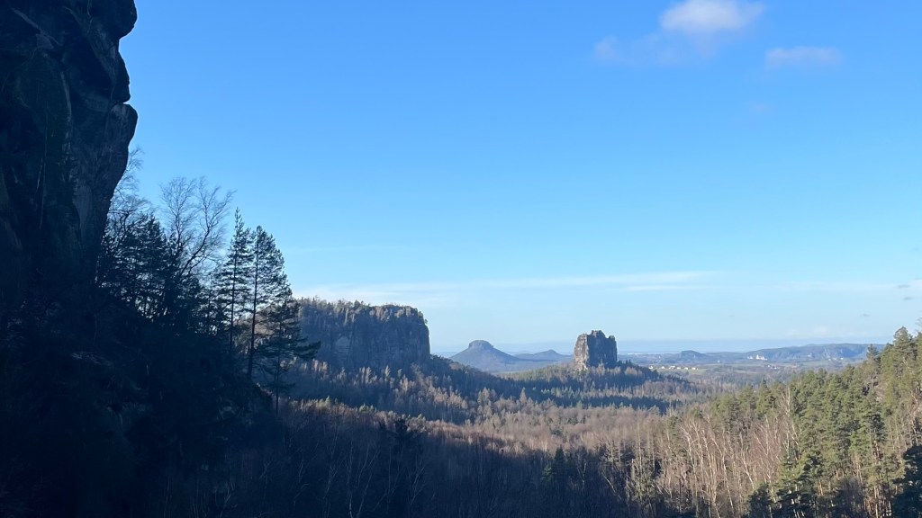
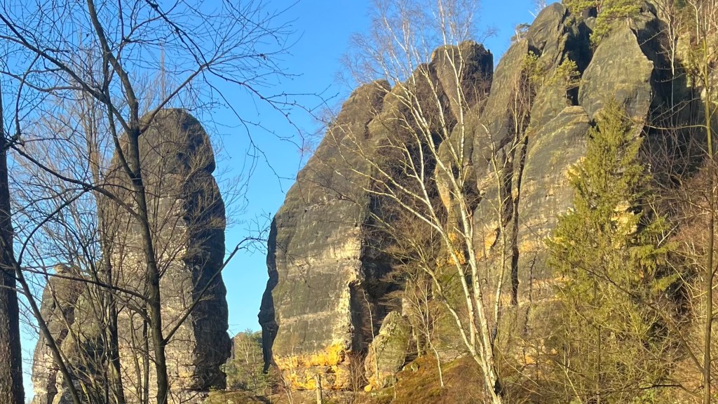
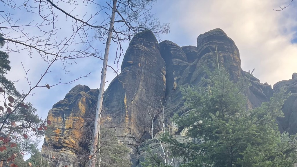
Named after the Romantic-era artists who immortalised the scenery of Sächsische Schweiz, the Saxon Switzerland National Park, the Malerweg (Painter’s Way) is a 112km trail that winds through dense forests, quiet villages and striking sandstone landscapes. There’s no shortage of stunning viewpoints, as the trail was designed to link the area’s most iconic viewpoints and rock formations. It’s no surprise that the trail is now one of Germany’s most famous long-distance hiking routes.
I section-hiked the trail in December 2024. For a closer look at the on-the-ground experience, head over to my Malerweg: Trail Journal post for my stats, budget, photos and story.
- Quick Facts
- Map & Elevation Profile
- Preparation
- On-Trail Practicalities
- Side Missions & Connecting Trails
- Hiking as a Solo Woman
- Want More?
Quick Facts
| Distance | 116 km |
| Elevation gain & loss | 2,300 m |
| Days to complete | 5-7 |
| Best season | Spring (April) to Autumn (October) |
| Trailheads | Pirna |
| Recommended direction | Clockwise |
Map & Elevation Profile
Preparation
Trailheads & getting there
The trail starts on the outskirts of Pirna in Liebethal, and ends in the town centre. Pirna is conveniently accessible via the Deutsche Bahn train network. For those arriving from other countries, Dresden and Leipzig airports are most convenient.
Direction to Walk
The trail can be walked in either direction, but you might like to stick with clockwise so you’re going down some relatively steep sections on stairs and ladders, rather than up them.
Season to Walk
The trail can be walked year round, and I had a fantastic experience walking it over winter. But an off-season walk can mean fewer accommodation and eating options are available. The trail is more often walked between April and October, peaking in summer. It runs through a number of very popular tourist destinations, so expect crowds in some sections in peak season.
Accommodation
Beds & Bunks
Plenty of hotels, hostels and self-catered apartments are peppered all along the trail, however the trail runs through a popular tourist area so book ahead in summer months. Some also close or offer limited services during winter.
Camping
Wild camping is not permitted, but it is possible to camp the trail year-round by staying in commercial campsites.
Gear List
Travel light by staying in accommodation. All you’ll need is:
- 2 sets hiking clothes (1 for wearing, 1 for washing/drying)
- Optional: end-of-day / town clothes
- 3x socks and underwear
- Hat or beanie
- Sunglasses
- Hiking shoes or trail runners
- Warm layers: fleece, puffer
- Rain layers
- Electronics
- Toiletries
- Optional: lightweight towel (if not provided by your accommodation)
In winter, worth bringing some traction for your shoes as well as some gloves.
Campers will need their tent (duh), as well as sleep system and cooking system. Or you could leave the cooking system at home and rely on the facilities provided at the campsites.
Possible Stages
The Saxon Switzerland Tourism Board divides the trail into these eight stages. But there are plenty of additional towns and villages directly on or close to the trail where you could break up your journey.
| Place | Distance from previous (km) (clockwise) |
|---|---|
| Liebethal (Pirna) | 0 |
| Stadt Wehlen | 11.5 |
| Hohnstein | 10.9 |
| Altendorf | 14 |
| Neumannmühle | 18.3 |
| Schmilka | 13.6 |
| Kurort Gohrisch | 17.3 |
| Weißig | 16.6 |
| Pirna | 13.8 |
On-Trail Practicalities
Finding Your Way
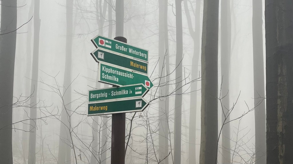
Trail Markings
The trail marker is a white square with a black M that aptly looks as though it has been slashed with a paintbrush. It’s most commonly found on green directional signs, but there are a few places where it’s been painted on trees as well. Trail marking is generally good, although in a couple of the more popular day-hiking sections, like near Bastei and in the National Park, it can be easy to miss the markers, so it’s worth bringing a map or app.
Maps & GPX
Physical maps are available from local tourism offices, or download the GPX files available in the Saxon Switzerland Tourism Board’s stage descriptions.
Guidebooks & Resources
There don’t appear to be any English-language guidebooks for the trail, although there is a German guidebook available. The Saxon Switzerland Tourism Board hosts a website in English and German on the trail: unfortunately all walking notes are only in German, but the truly dedicated could run the notes through Google translate.
Food & Water
The trail passes through numerous villages and towns, so resupply isn’t a problem. The larger towns like Pirna and Bad Schandau offer several supermarkets, as well as restaurants, cafes and bakeries.
Water refills are easy at all these villages and towns. Although there are natural sources dotted along the trail, filtering is essential.
On-Trail Transport
This trail is very well-served by a network of public transport, including trains, buses and trams. Most types of accommodation in the region require payment of a tourist tax; in return you’ll receive a ticket that gets you free use of public transport in the area. This is a great trail to section-hike from a single “base” where you can leave most of your gear behind; Bad Schandau is probably the most central option.
Money Matters
Card is accepted in most cases, but it will pay to carry a little cash on you in case you need to catch a bus.
For an idea of what I spent staying in accommodation on-trail, head over to my Malerweg: Trail Journal.
Side Missions & Connecting Trails
There are a couple of worthy side missions from this trail. In Bastei, a short detour from the main path offers the chance to clamber over rock formations and inspect the famous Bastei bridge from every angle. The Schrammsteine Ridge will tempt the adventurous, offering ladders to lookout points. It’s accessed from either Schmilka or Bad Schandau on-trail. If you’re searching for a 360 degree view of Saxon Switzerland, you’ll want to take a 2-3 hour detour from Schhöna or Bad Schandau to climb the table-top Lilienstein mountain.
Hiking as a Solo Woman
I hiked this trail solo in winter, and felt perfectly at ease the entire time. The trail was quiet and peaceful, although people were still out and about on it. The busiest section was Bastei, but other than that I only came across a handful of people each day. The locals were very friendly and accommodating, and mobile reception was generally good. This would be a great first solo hike for anyone.
Want More?
Check out my Malerweg: Trail Journal for stats, stories and snapshots from the trail.

Leave a comment